You remember the controversial Google Mapathon contest, where Google had asked users to help build location point of interest data. Google had got into trouble with it, as security agencies were of the opinion that it may be a threat to national security.
Now ISRO’s Bhuvan, who themselves have satellite map imagery of India have taken the same approach as Google maps to collect localized point of interest data.
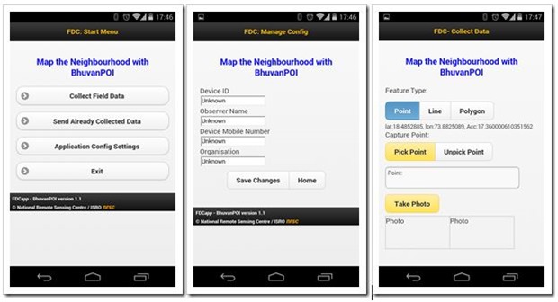
They have released a new Android mobile app called – BhuvanPOI, (Interestingly, it is not available on Play Store), that allows app users to collect “points of interest” location data and send it to Bhuvan database, which eventually will start showing up on their maps, just like Google does.
We downloaded the app and played around with it for sometime. Though, the user interface is not that great (which is expected), the app surprisingly works very well. The app immediately located GPS co-ordinates of the location and I could upload the “Point of Interest data” quite easily.
How Bhuvan Android App Works
User will first need to download the apk, as it is not available on Android play store. Once the APK is installed, the user will need to first fill the “Application configuration settings”, which includes device ID, Name of observer, Mobile number and name of organization (Not sure why do they need mobile number of the user)

Once your config settings are saved, you are all set to upload the location or point of interest data from your smartphone.
The app allows users to send data immediately, or they can save multiple locations and then send it later all at one time.
The app has multiple options, as it you can choose to send data about a particular point, or a straight line or closed polygon, where you can map a particular area of field. In addition to this, users can also click neighborhood photos and send it.
When you upload a particular “point of interest” information, the user needs to categorize it using the list available within the app, which includes various POI heads like ATM, College, Library, Hospital and more.

Our Take
Like I mentioned, the app does not have a great UI, but the functionality works like a charm. The latitude and longitude data was precise and fast. If Bhuvan can have popularize this app and get heavy downloads, they can surely collect good data that will add tremendous value to Bhuvan Maps.

why not integrate with google maps and help each other rather than fighting.. can you guys tell this to ISRO ?
Ironical isn’t it! The government need not prove to anyone that the activities they take up is not going to be a threat to the country while they cripple any private player big time through their archaic rules. But the big question is all this data sourced from the public, will it be available to the public to build services upon it? Will NRSC give it back to the people in the form of some API is a big question. Despite all criticism, Google maps has been used in innumerable ways to build so many useful for profit and not for profit purposes. Lets hope we don’t need to exercise RTI to get access to this data ;)